
A little over a month before Hurricane Milton hit St. Petersburg, Fla., as a Category 3 storm last October, Chris McPherson purchased two companies: Southeastern Marine Power and Yacht Power Products. He combined the two service and repower facilities into a new company called Southeastern Marine & Yacht Power.
“We had a great September with the companies combined, and Milton hit the second week of October, blew the roof off our showroom and destroyed millions in inventory,” McPherson says.
What saved the new company was planning based on weather forecasts. “We were staring down the path, and it was supposed to be a direct hit, so we packed up technicians’ tools and [diagnostic] computers,” McPherson says. “We’re known for our mobile service, so we took all that stuff way north and inland to some secure facilities.”
That kind of foresight for marine-industry businesses is more possible than ever this year, with the National Oceanic and Atmospheric Administration’s Hurricane Analysis and Forecast System now updated to improve rapid intensification prediction by 5% to 7%. Additionally, instead of just forecasting a storm, scientists can now break out storm surge, rainfall and tornadoes, creating warnings for each phenomenon. Ken Graham, director of the National Weather Service, says that five days out from a storm, experts can now predict landfall within 200 miles. “In the last 10 years, we have improved tracking by 50%,” he says. “Helene was forecast as a major hurricane before it even developed. NOAA predicted Milton’s rapid intensification on four days’ notice.”
NOAA’s prediction in 2024 was for up to 25 named storms, with eight to 13 of them major hurricanes. Looking ahead, in its first forecast of 2025, Colorado State University’s Department of Atmospheric Sciences predicted 17 named storms and nine hurricanes, with four major storms having a rating of Category 3 or higher. Similarly, NOAA’s National Hurricane Center forecasters are predicting 13 to 19 named storms with six to 10 becoming hurricanes and three to five making landfall as Category 3 or higher.
As McPherson learned in St. Petersburg, the time for marine business owners to start thinking about preparations is today.
Crawling From the Wreckage
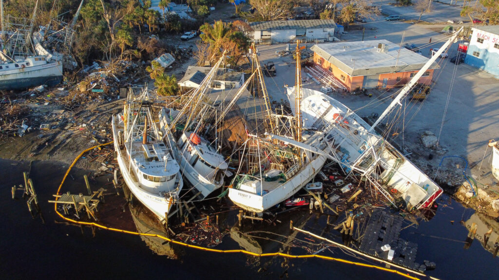
The day after Milton struck, McPherson drove past his company headquarters that housed offices and an engine showroom. “Things looked pretty good, and then I drove around back and saw the roof sitting on top of one of our Ford F-450 trucks,” he recalls. “The entire showroom was carnage. What was left of the roof had collapsed on all our display engines.” On the plus side, the truck had been parked in front of an oil-disposal shed — on purpose — to protect the storage unit from becoming an environmental disaster.
After assessing the damage to his facilities, McPherson messaged his 30 employees to make sure everyone was accounted for. “Those we didn’t hear from, we drove to their house to make sure they were OK,” he says.
That night, he sent out a group text asking employees who didn’t suffer damage at their homes to come to work the next day. They created temporary offices, got a roofing company to tarp the building, and switched to a digital phone system. Some team members went to the inland facilities to bring back the tools and diagnostic computers. “We had call after call after call from customers,” McPherson says. “My team got to work and kept going.”
Milton hit Southeastern Marine & Yacht Power as a Category 3 hurricane, with 14 inches of rain. McPherson couldn’t get the city’s approval to put on a new roof until March of this year. At the end of May, the company was hoping to have a new roof in six to 12 weeks.
During the interim, McPherson went to local marinas and asked if he could lease, sublease or buy a property. He came across Maximo Marina in St. Petersburg. Initially, management wasn’t interested, but McPherson persisted and acquired the operations of the boatyard. He will bring in Southeastern Marine & Yacht Power, and the new facility will be known as the Boca Ciega Marine Center.
“When there wasn’t anything reasonably available, I could have shut it down, gotten the insurance check and sold the company, but I want it to be here another 20, 40 years,” McPherson says.
Another facility hit by Milton was Fisherman’s Wharf Marina in Venice, Fla., where a 200-foot fixed dock was destroyed and the company had to replace a floating dock and a bait tank.
“I didn’t know if I’d have a job to come back to,” says dockhand Kya Collins, who lives on Venice Island. “There were police cars going down the street saying, ‘Get out of here.’ I stayed, but I was definitely scared. We were without power for a couple weeks, and I remember how good it felt just to have a hot meal.”
Early Predictions
Isaac Schluesche, a Colorado State University graduate research assistant, says the main factor for the university’s 2025 forecast numbers is that sea surface temperatures in the Atlantic are still warmer than average, even though they are down a couple of degrees compared with last year. “We’re not seeing the record-breaking averages of last season,” he says. “But it’s still the third warmest in the last five years.”
Warm water temperatures and other atmospheric conditions can transition a storm that is barely formed into a major hurricane in a short time, through the process of rapid intensification. This has happened in areas like Fort Myers Beach, Fla., which has been hammered by large storms more than once in the past five years. “Every category 5 storm that has hit this country was a tropical storm less than three days prior,” Graham says.
Colorado State’s researchers say the tropical Pacific at the end of May was characterized by a weak La Niña condition that is expected to transition to an El Niño-Southern Oscillation neutral condition during June and July. There is uncertainty about the phase ENSO will be in during the peak of hurricane season, from August through October, but NOAA is estimating the odds of an El Niño at 13%. This is generally associated with hurricane-conducive upper-level wind conditions in the tropical Atlantic.
Another phenomenon experts are examining more closely is what they call the Expanding Bull’s-Eye Effect. It looks at how storms affect an area that has undergone extensive, rapid urban development.
A good case study of this was Hurricane Harvey, which hit coastal Texas in 2017. Harvey fed off the Gulf of Mexico’s warm waters and overwhelmed Houston with rain and storm surge. Much of the shoreline was covered in pavement and concrete, so there was no soil to absorb all that water.

Don’t Count on Luck
Brian McNoldy, a senior research associate at the University of Miami’s Rosenstiel School of Marine, Atmospheric and Earth Science, says he can’t see a strong mechanism to force an active season or a weak one. “We’ll be in neutral territory for ENSO, and ocean temperatures are a mixed bag of warm and cool anomalies,” he says. “In the end, much of it comes down to luck, and even if it is an active season, you might not get hit.”
Take the Miami-Fort Lauderdale area as an example. It hasn’t experienced a direct hit from a hurricane since Andrew in 1992. “Every year, we have a 15% to 20% chance of getting hit,” McNoldy says. “But 50 miles can make the difference between having a house and not having anything left.”
He says the Caribbean is still warmer than average, and in the deep tropics, conditions usually remain consistent. “You don’t deal with huge changes in sea-surface temperature or outflow temperatures for the hurricane,” McNoldy says. “What matters is the temperature difference between the two.” An unstable atmosphere, he adds, is good for hurricane development.
Still Above Average
NOAA’s prediction for an above-average season is based on research done by 16 meteorologists in the National Hurricane Center’s Tropical Analysis and Forecast Branch. “You should not do anything different each year to prepare, so if we’re saying one storm overall or 15 overall, you should always prepare as if you’re going to get whacked,” branch chief Chris Landsea says.
Landsea says a warm Caribbean and Atlantic are indicators for an active season. Warmer waters in the Gulf of Mexico the past few years have helped storms gain strength before hitting Florida’s southwest coast.
For 2025, Graham says, NOAA and the University of Miami have added more small aircraft, drones and underwater gliders, and upgraded the oceanic buoy array, to improve forecasting accuracy and lengthen lead times. “Track and intensity forecasts are going to be better than ever, and we’re going to be able to expand it from 48 hours to 72 hours this year,” Graham says.
The new forecast cone, which was experimental last year, is now operational — though Graham stresses that the impacts of a storm extend well outside the cone. It only points out where the center of a storm is.
The biggest challenge remains educating the public to stay vigilant. “Social science tells us that people latch on to that first forecast,” Graham says. “It’s not about the category. Only 1 mph separates the categories. You need to focus on the impact. The bigger the storm, the slower the storm, the bigger the impact.”


