
With the start of the Atlantic hurricane season June 1, forecasters at Colorado State University’s Department of Atmospheric Science are predicting a lower-than-average number of storms. CSU is also forecasting a below-average probability for major hurricane landfalls along the continental U.S. coastline and in the Caribbean.
In addition, forecasters see a moderate to strong El Niño episode as a dominant factor this season, driving increased vertical wind sheer that can tamp down hurricane activity. Taken together, these predictions suggest that marine businesses and the industry might breathe a bit easier this year.
CSU, in its initial forecast released April 9, predicted 13 named storms for the season, which runs through Nov. 30. Six storms are expected to become hurricanes (with winds of 74 mph or greater), and two are predicted to become major hurricanes (with winds of 111 mph or greater).
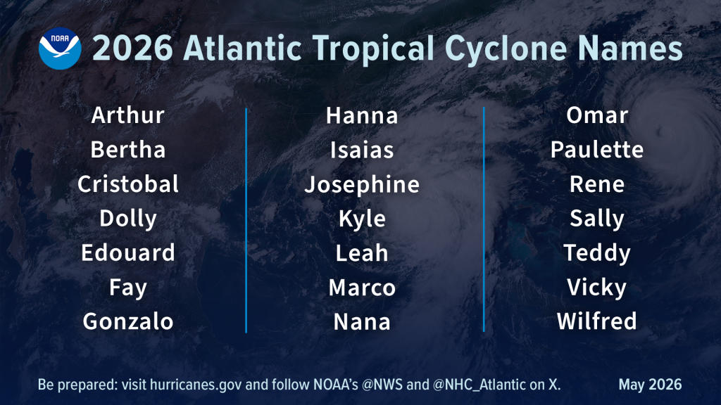
On average, the Atlantic hurricane season sees 14 namedstorms, seven of which become hurricanes, with three of those reaching major status.
CSU said there is a 32% probability of a major hurricane making landfall along the U.S. coast (the average from 1880 to 2020 was 43%), including the Florida peninsula at 15% and the Gulf Coast from the Florida Panhandle to Brownsville, Texas, at 20%. Those Florida and Texas probabilities are lower than the historical average, while the probability is 8% higher than the historical average for a major hurricane making landfall in the Caribbean.
“The number one takeaway is that the forecast is for a below-average season, and number two is that it is because of the upcoming forecast for El Niño,” says CSU research scientist Levi Silvers, a co-author of the April forecast.
The National Oceanic and Atmospheric Administration’s National Hurricane Center, in its forecast released May 21, predicted eight to 14 named storms, with three to six becoming hurricanes and one to three of those reaching major status. NOAA predicted a 35% chance of a near-normal season, a 10% chance of an above-normal season and a 55% probability of a below-normal season.
“For us, it’s an opportunity to say hurricane season is here and you need to get ready,” says Christopher Landsea, chief of NOAA’s Tropical Analysis and Forecast Branch. “We provide a range because we know we’re not going to get it exactly right.”
Complacency Concerns
The announcement of a less-active season can be a bit of a double-edged sword because when people hear “below average” and “fewer storms,” they might be less vigilant. “You can have a below-average season that is still impactful,” says Brian McNoldy, senior research associate at the University of Miami’s Rosenstiel School of Marine, Atmospheric and Earth Science. “It just depends on where those storms hit.”
For example, the 1992 preseason forecast called for below-average activity, and Hurricane Andrew made landfall near Homestead, Fla., in August as a Category 5 storm with 165-mph winds. Andrew killed 65 people, destroyed more than 63,500 homes, damaged more than 124,000 others and caused $27.3 billion in damage.
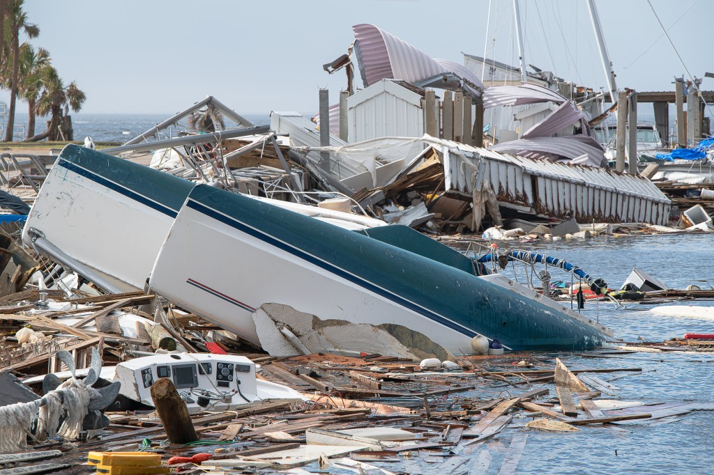
Last year, no named storms made landfall along the U.S. coast, but Hurricane Melissa hit near New Hope, Jamaica, with sustained 185-mph winds, the strongest storm to ever hit the island. “Does a below-average prediction seasonal forecast mean you don’t have to prepare as much? The answer is no,” Landsea says.
Forecasters cited a developing El Niño episode that creates unusually warm water temperatures in the Eastern Pacific and disrupts global wind and weather patterns as a leading factor in their 2026 predictions. As of late May, the models were in agreement for a strong El Niño, comparable to 2015 and 2016. In 2023, a strong El Niño kept the number of storms down, but Hurricane Idalia hit northern Florida in August as a Category 4 storm, then pushed into southeast Georgia and the Carolinas, causing significant damage.
Idalia transformed from a tropical storm into a major hurricane in a phenomenon called rapid intensification, fed by higher-than-normal surface temperatures in the Gulf of Mexico and the Atlantic. The Gulf has been trending warmer than average during summer. “Small changes matter, especially for things like a hurricane, because a hurricane cares about how warm the ocean surface is and how cold the outflow level is at the top of the storm,” McNoldy says. “They are equally important because it’s the difference between them that feeds the engine.”
Silvers adds: “We know beyond a shadow of a doubt that the Gulf of Mexico is going to be warm enough to support a storm.”
Better Forecasting
NOAA and the National Weather Service have been developing ways to better inform the public about what to expect from storms well before they strike. This year, NOAA’s forecast cone will include tropical storm and hurricane watches and warnings for inland areas. An experimental phase last year demonstrated that the improved forecast cone enabled inland communities to better understand and prepare for tropical cyclone winds.
“We’re trying to get the point across that a hurricane isn’t a dot,” Landsea says. “It has extent that can be fairly large, and it has inland effects.” The new cone graphic incorporates all land-based (coastal and inland) tropical storm and hurricane watches and warnings for the continental United States, Hawaii, Puerto Rico and the U.S. Virgin Islands.
This year, an experimental forecast cone will capture a wider and more realistic range of potential storm paths. Also, rather than using fixed circles anchored at each National Hurricane Center forecast point, the experimental cone uses ellipses to account separately for the speed of the storm (along-track error) and its directional movement (cross-track error). And the new cone expands to 90% probability from the traditional 67%, which means the center of a storm is expected to stay within the cone nine out of 10 times to better reflect risk.
NOAA’s Office of Water Prediction has developed flood inundation mapping to better monitor areas that could be in danger of flash flooding from rain, rivers and coastal storm surge. The Weather Prediction Center in College Park, Md., also launched an Urban Rain Rate Dashboard, a real-time tool that shows the probability of extreme rainfall a week in advance for more than 60 U.S. cities.
NOAA’s hurricane-hunter aircraft have updated Doppler radar with machine learning that gathers 25% more meteorological data than the current method to better inform storm structure and wind analysis. The researchers also have been experimenting with uncrewed aircraft that can launch from the planes, a vessel or shore.
CSU has been working with a machine-learning-based climate model called the Ai2 Climate Emulator. It’s run with predicted sea surface temperatures from the European Center for Medium-Range Weather Forecasts climate model, one of three models used to create broadcasts. “The idea is trying to use a machine-learning tool to get a better understanding of the statistics,” Silvers says.
Landsea says the some of the biggest advances have been with satellite technology that improves communications and how people receive forecasts. “In the past, we would use radio technology,” he says. “Now most folks have high-speed internet over the ocean, and they’re accessing weather information through Windy.com and other sources.”
The science behind hurricane forecasting is making big advances, and a below-average season is a welcome prediction for the industry, but nothing replaces being vigilant and prepared when a storm is on the radar. “Regardless of where you are, if your locale is under threat of a hurricane, take it seriously,” McNoldy says. “If the forecasts are high, low — it doesn’t matter because any of these storms could end up in your neck of the woods, and you better be paying attention.”


